How Machu Picchu Was Built
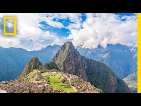 Photo: N43 and Hermes
Perched on a razor-thin ridge 2,430 meters above the Urubamba River, the 15th-century Inca citadel of Machu Picchu is an engineering feat that defies its remote, earthquake-prone, cloud-wrapped setting. Its ashlar walls, terraced agriculture, and hidden drainage system were the product of a civilization that built without iron tools, the wheel, or mortar.
Source video: Machu Picchu 101 | National Geographic · National Geographic · approximately 3.5M views observed via yt-dlp on August 4, 2026. Independently researched by N43 and Hermes.
Figure 1 — Timeline of Machu Picchu from its founding under Pachacuti to its rediscovery by Hiram Bingham in 1911.
01 The Royal Estate and Why It Was Built
Machu Picchu was not a city in the conventional sense. It was a royal estate commissioned by the ninth Sapa Inca, Pachacuti Inca Yupanqui, who ruled from approximately 1438 to 1471. The site functioned as a seasonal country palace, a religious sanctuary, and an administrative center for the surrounding region. The Inca emperors maintained a network of such estates across the Sacred Valley, each designed to project imperial power and provide a retreat from the capital at Cusco.
The choice of location was deliberate. At 2,430 meters above sea level, on a saddle between the peaks of Machu Picchu and Huayna Picchu, the citadel sat above the Urubamba canyon in a zone of subtropical mountain climate. The ridge was defensible, visually spectacular, and close enough to Cusco for royal processions yet remote enough to discourage casual intrusion. The Inca had no written language, so the planning logic must be reconstructed from the architecture itself: a site chosen for its relationship to sacred mountains, its access to water, and its capacity to feed a permanent population through intensive terraced agriculture.
Archaeologists estimate that between 500 and 750 people lived at Machu Picchu at its peak, most of them support staff, artisans, and religious specialists serving the Inca court. The estate was likely occupied for less than a century before it was abandoned during the Spanish conquest, probably in the 1570s. The Spanish never reached the citadel, and its existence passed from living memory into oral tradition until Hiram Bingham brought it to international attention in 1911.
02 Site Preparation: Earthquakes, Rain, and the Ridge
The greatest engineering challenge at Machu Picchu was not the stonework but the ground beneath it. The ridge is composed of fractured granite interspersed with fault lines, and the region receives roughly 1,955 millimeters of rainfall annually. A site this steep, this fractured, and this wet would have been prone to catastrophic landslides had the Inca not intervened at the most fundamental level.
Before a single wall was raised, the Inca engineers reshaped the ridge itself. They excavated the fractured rock and packed the voids with crushed stone and gravel, creating a deep, well-drained substructure. In some areas the fill extends more than three meters below the visible ground level. This buried layer acted as both a foundation and a drainage system: rainwater that would otherwise saturate the soil and trigger a slide percolated through the crushed stone and was channeled away through a network of subterranean drains.
The ridge was also terraced on multiple levels. The agricultural terraces on the eastern and western flanks served not only to create flat planting surfaces but to buttress the entire hillside against the gravitational forces that would have eventually pulled an unmodified slope into the canyon. Each terrace wall was built with a slight inward lean and a foundation of coarse gravel, so that seismic shaking would cause the walls to compress tighter rather than collapse outward. The terraces also contained layered soils: gravel at the base for drainage, sandy subsoil above, and rich topsoil on the surface, with a total depth of up to one meter in some profiles.
Figure 2 — The gap between adjacent stones in the finest ashlar walls is less than 1 mm, narrower than a modern brick mortar joint.
03 The Ashlar Stonework: How the Walls Were Built
The defining visual feature of Machu Picchu is its ashlar masonry. The most important structures, including the Temple of the Sun, the Royal Tomb, and the principal sacred buildings, were constructed from precisely shaped granite blocks fitted together without mortar. The joint between adjacent stones is typically less than one millimeter, a tolerance so tight that a razor blade cannot be inserted between them.
The Inca had no iron tools. They worked the granite with harder stones used as hammerstones and chisels, grinding and shaping the blocks through patient abrasion. The most likely method involved a combination of percussion flaking with hammerstones to rough out the block, followed by grinding with abrasive grit, possibly quartz sand and water, to achieve the final fit. Each stone was shaped individually against its neighbors. The technique of fitting each block to its specific position rather than to a standardized template is visible in the irregular polygonal shapes of many wall stones, particularly in the less prominent structures.
The finest walls, those associated with ceremonial and royal functions, show the tightest joints and the most regular courses. Rougher walls, used for warehouses and secondary buildings, have larger joints of 10 to 15 millimeters filled with clay and gravel mortar. This hierarchy of craftsmanship was itself a social statement: the most skilled stonemasons were deployed where the architecture needed to communicate sacred or political authority.
04 The Water System: A Spring, A Canal, Sixteen Fountains
Water was the axis around which Machu Picchu was organized. A natural spring on the northern side of the ridge, fed by rainfall percolating through the mountain, was the site's only reliable water source. The Inca engineered a collection system at the spring, lined with stone, that gathered the water into a single channel. From there a canal carried it 749 meters along the ridge to a series of sixteen fountains that cascaded down the hillside through the center of the citadel.
The canal was built with a precise gradient, approximately 3 percent, steep enough to keep the water flowing but gentle enough to prevent erosion of the channel. The fountains were stone basins arranged in a sequential cascade, each fed from above and draining to the one below. This was not merely decorative: the cascade provided clean, aerated drinking water at successive points through the settlement, and the flow rate was calibrated to the spring's output so that the system never ran dry and never overflowed.
A parallel drainage system ran beneath the agricultural terraces. The terraces themselves were designed with a 5 percent slope toward stone drain outlets, and the subsurface layers of gravel and crushed rock ensured that excess rainwater was channeled away from the retaining walls. This dual system, potable water in the fountains and storm drainage in the terraces, was integrated into the site plan from the beginning. The water system was not an afterthought; it was the primary constraint on the layout, and the architecture was organized around it.
05 The Terraces: Feeding a Mountain Citadel
Machu Picchu was surrounded by approximately 700 agricultural terraces covering a total area of roughly five hectares. These terraces transformed steep, unusable slopes into productive farmland. The soil in the terraces was not native to the ridge; it was carried up from the valley below, a labor investment that underscores the scale of the Inca logistical operation. Each terrace was a layered structure: a base of large stones for drainage, a middle layer of sand and gravel, and a top layer of rich imported soil up to one meter deep.
The terraces were used to grow maize, potatoes, and other Andean crops. The stepped design created microclimates at different elevations, allowing diverse crops to be cultivated simultaneously. The stone retaining walls of the terraces absorbed solar heat during the day and radiated it at night, protecting the crops from frost at an altitude where nighttime temperatures could drop below freezing.
Beyond the agricultural function, the terraces served as structural engineering. They stabilized the hillside, prevented erosion, and redistributed the weight of the citadel above. The retaining walls were built with the same inward lean and crushed-stone foundations as the residential walls, so that seismic events would compress the wall tighter against the earth behind it rather than pushing it outward. The terraces and the subterranean drainage system together constituted a geotechnical engineering solution that has kept the ridge stable for more than 500 years despite the conditions that would have caused a conventional hillside to fail.
06 Quarry, Transport, and Labor
The granite for Machu Picchu was quarried from the ridge itself. The primary quarry site, located on the south side of the citadel, yielded the raw blocks that were shaped into the ashlar walls. The stone was extracted by splitting natural fractures in the granite, using wooden wedges soaked in water to expand the cracks, and by percussion with harder hammerstones. The distance from quarry to construction site was at most a few hundred meters, but the blocks had to be moved uphill and across irregular terrain.
The Inca had no wheeled vehicles or draft animals capable of carrying large loads, though llamas were used for lighter transport. Large stones were moved by human labor, using ropes, levers, and ramps. The absence of the wheel was not a technological deficit but a response to the terrain: wheeled vehicles are useless on steep, narrow mountain paths. Estimates suggest that a workforce of several hundred to a few thousand laborers was involved in the construction over a period of several decades.
The labor force was organized through the mita system of rotational corvee labor, in which subject communities were required to provide labor to the state for fixed periods. This was the same system that built the Inca road network and the agricultural terraces throughout the empire. The workers at Machu Picchu included stonemasons, quarrymen, transport teams, and agricultural laborers. The estate was built not by slaves but by communities fulfilling their obligations to the Inca state, a form of taxation through labor that was the economic engine of the empire.
07 Abandonment and Survival
Machu Picchu was occupied for less than a century. By the time the Spanish arrived in Peru in 1532, the estate had likely already been depopulated as the Inca political system collapsed under civil war and foreign invasion. The Spanish never found the citadel, partly because it was hidden by the same geography that made it difficult to reach and partly because the Inca deliberately concealed routes to remote sites during the conquest. By the late 16th century, the site had passed from living memory.
The stonework survived because it was built to survive. The ashlar walls, fitted without mortar, have withstood five centuries of earthquakes that have destroyed colonial-era buildings in Cusco and the surrounding valley. The drainage system continued to function even after the site was abandoned, because the buried layers of crushed stone were self-maintaining. The terraces held the hillside in place without human intervention. The result is a rare case in which the engineering outlasted the civilization that created it, not by accident but by design.
Today Machu Picchu faces new threats from tourism, erosion, and geological instability. The ridge itself sits on a fault line, and geologists have identified slow-moving landslides on the slope below the citadel. The same forces that the Inca engineers countered five centuries ago, gravity, water, and seismic activity, continue to act on the site. The question for the 21st century is whether modern conservation engineering can match the durability of the 15th-century solution.
References
- Wikipedia: Machu Picchu — overview, history, and architecture
- Wright, K.R. & Valencia Zegerra, A., Machu Picchu: A Civil Engineering Marvel, ASCE Press — drainage, water system, and terrace engineering analysis
- UNESCO World Heritage Centre, Historic Sanctuary of Machu Picchu — World Heritage listing and description
- Britannica, Machu Picchu — historical and archaeological summary
- Source video: Machu Picchu 101 | National Geographic (National Geographic, ~3.5M views, observed August 4, 2026)
By N43 and Hermes for Sailor Bob News.


