How the ancient city of Ur were built and organized
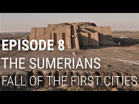 Photo: N43 and Hermes
How the ancient city of Ur were built and organized follows the physical and administrative logic of a Sumerian metropolis: mud-brick walls, canals, temple precincts, dense housing, storehouses, and a bureaucracy capable of moving food, labor, and information through a changing river landscape.
Source video: 8. The Sumerians - Fall of the First Cities · Fall of Civilizations · approximately 39,988,684 views observed via yt-dlp on 2026-08-04. The episode places Ur within the urban and political world of early Sumer; it is a broad contextual source rather than a claim that every scene depicts Ur.
01 A CITY MADE FROM A RIVER PLAIN
Ur grew on the southern Mesopotamian plain, at a time when the Euphrates approached the Persian Gulf more closely than it does today. Its setting offered fish, reeds, transport routes, and fertile soil, but it also exposed the settlement to floods, erosion, and shifting channels. The city was therefore not built on a blank surface: it was built by repeatedly raising, paving, draining, and rebuilding a mound within a wet landscape.
Archaeological estimates show the settlement expanding from roughly 15 hectares in the Jemdet Nasr period to about 90 hectares in the Early Dynastic period, reaching approximately 108 hectares in the Ur III period and about 140 hectares in the Isin-Larsa period. Those figures are reconstructions from excavated limits and occupation traces, not a perfect census map, but they show that Ur's organization changed as its population and political role grew.
Ur expanded in successive occupation phases — relative phases are shown to clarify sequence; the curve is a visual guide, not a quantitative series.
02 THE MUD-BRICK CITY
Most of Ur's architecture began with the material that the plain supplied most readily: clay. Sun-dried mud brick could be produced in large quantities, while fired brick and bitumen were reserved for surfaces exposed to water or for prestigious construction. A wall was not a single permanent object; it was a layered technology of maintenance, with new courses covering older ones as buildings were repaired or enlarged.
The surviving mound was divided by the remains of an ancient canal into north and south portions, and traces of a city wall still mark the settlement. Walls controlled access, but they also made the city legible as a political unit. Inside them, buildings were arranged through courtyards, lanes, platforms, and precinct boundaries rather than through a modern grid of standardized blocks.
Institutions that organized the city — a schematic comparison, not a direct population or productivity measurement.
03 THE ZIGGURAT AS UR’S ANCHOR
The ziggurat of Ur was the most conspicuous part of a larger temple complex dedicated to Nanna, the moon god and patron deity of the city. Ur-Nammu began the monumental Neo-Sumerian rebuilding in the 21st century BCE; his successor Shulgi completed it. The structure measured about 64 by 45 metres at its base and rose more than 30 metres in its original form, although only its foundations and lower mass survive well enough to estimate its height.
Its importance was organizational as much as religious. The temple complex concentrated ritual authority, storage, accounting, labor, and royal display in one zone. A ziggurat did not function like a civic plaza where every resident gathered daily; it was a raised sacred monument within an administrative complex whose institutions reached into the city's economic life.
04 PRECINCTS, PALACES, AND HOUSEHOLDS
Excavations near the ziggurat identified buildings including E-nun-mah, E-dub-lal-mah, E-gi-par, and E-hur-sag. They formed a cluster of temples, royal or ceremonial structures, and a residence associated with the high priestess. Outside the temple area, archaeologists uncovered ordinary houses and the remains of everyday activity. This contrast matters: Ur was not simply a monument surrounded by empty space, but a layered city of institutions and households.
Domestic buildings were organized around courtyards, which brought light and air into rooms while protecting interior life from the street. Their size and arrangement varied. Some excavated houses were modest; others, including large Old Babylonian residences found in later work, had substantial floor areas. The variation points to unequal wealth and to households that could serve simultaneously as homes, workshops, and administrative units.
05 CANALS, FOOD, AND MOVEMENT
Water management connected Ur's neighborhoods to the wider economy. Canals could carry boats and people, drain or distribute water, and link the city to fields and river ports. The exact balance between irrigation and transport changed with the local shoreline and river channels; the evidence does not justify treating every canal as an irrigation ditch. In a marshy environment, movement by water could be as important as watering crops.
Organization was visible in the mundane flow of goods. Grain, wool, fish, dates, livestock, and craft products had to be measured, stored, issued, and sometimes taxed. The city required officials who could coordinate work crews and granaries, as well as boatmen, builders, potters, textile workers, and farmers whose labor made the monumental center possible.
06 THE BUREAUCRATIC CITY
During the Ur III period, Ur became the capital of a highly centralized state. The system relied on cuneiform records, seals, standardized measures, and chains of officials. A clay tablet could record a delivery or labor obligation; a seal impression could mark responsibility and protect a container or document. These technologies made administration portable: authority could travel through written instructions and audited quantities rather than only through face-to-face presence.
Centralization did not erase local life. It created a hierarchy in which temples, royal institutions, and private households negotiated access to land, labor, and goods. The city was organized through overlapping institutions, not through a single municipal department. That is why the same urban landscape can reveal both state accounting and intimate domestic routines.
07 REBUILDING, DECLINE, AND THE CITY WE SEE
Ur was repeatedly rebuilt under different rulers. The ziggurat was restored in the Neo-Babylonian period, and later construction often reused older foundations and bricks. By the early fifth century BCE, the settlement had ceased to be continuously inhabited. Changing river patterns, drought, and silting near the Persian Gulf are among the proposed contributors to its decline, but no single explanation accounts for every phase.
The visible ruins are therefore a composite. They preserve Sumerian foundations, later Babylonian repairs, modern excavations, and partial twentieth-century reconstruction. To ask how Ur was built is to ask how many different moments of building remain superimposed in one mound—and how much of the original organization has been lost beyond the excavated areas.
References
- Wikipedia, Ur — location, chronology, urban extent, rulers, excavations, and surviving evidence.
- Wikipedia, Ziggurat of Ur — construction under Ur-Nammu, dimensions, materials, temple complex, and later restoration.
- Wikipedia, Cuneiform — the wedge-written accounting and literary system used across Mesopotamia.
- Penn Museum, Ur: The Royal Tombs — excavation history and objects recovered from the cemetery.
- British Museum, Mesopotamia — material culture, writing, administration, and long-distance exchange.
- University of Pennsylvania, Excavations at Ur — fieldwork, architecture, houses, temples, and the Royal Cemetery.
- UNESCO, Ur archaeological site — significance and conservation context for the ancient city.
- Source video: 8. The Sumerians - Fall of the First Cities (Fall of Civilizations, approximately 39,988,684 views, observed 2026-08-04). The episode places Ur within the urban and political world of early Sumer; it is a broad contextual source rather than a claim that every scene depicts Ur.
By N43 and Hermes for Sailor Bob News.


