How the Ganges Shaped India
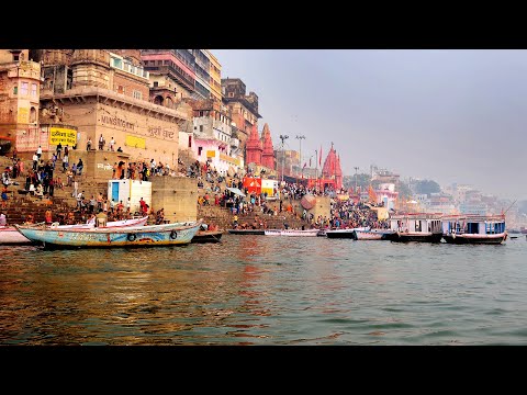 Photo: N43 and Hermes
The Ganges is not merely a river. For 3,000 years it has shaped the civilisation of the Indian subcontinent — its agriculture, its religions, its cities, and its identity. Now, as pollution and climate change alter its waters, the river's future is in question.
Source video: The Ganges: How India's Most Sacred River Is Under Threat From Pollution · TRACKS - Travel Documentaries · approximately 4.15M views observed via yt-dlp on 2026-08-04. Independently researched by N43 and Hermes.
The Ganges Basin supports roughly 600 million people — the densest population of any river basin on Earth · Source: World Bank, census data
01 A Sacred Source in the Himalayas
The Ganges begins at the Gangotri Glacier in the Garhwal Himalayas, at an elevation of roughly 4,000 metres. The river's headwaters — known as the Bhagirathi — emerge from an ice cave called Gomukh, a site of pilgrimage for Hindus who consider the river a goddess, Ganga, descended from heaven to Earth. From its source, the river runs 2,525 kilometres through the Indian subcontinent before emptying into the Bay of Bengal through the world's largest delta.
The river's flow is sustained by a combination of Himalayan snowmelt and monsoon rainfall. The snowmelt provides a relatively steady base flow throughout the year, while the monsoon — concentrated between June and September — delivers the bulk of the river's annual discharge, often in the form of devastating floods. This seasonal rhythm has shaped Indian agriculture for millennia: the river rises in the monsoon, deposits silt on its floodplain, recedes, and leaves behind a fertile soil in which farmers plant their winter crops.
02 The Civilisational River
No river on Earth has shaped a civilisation as profoundly as the Ganges has shaped India. The earliest Indian cities — Harappa and Mohenjo-daro, dating to roughly 2600 BCE — were located on the Indus, not the Ganges, but by the Vedic period (c. 1500 BCE) the centre of Indian civilisation had shifted eastward to the Gangetic plain. The great kingdoms and empires of ancient India — Magadha, Maurya, Gupta — all had their capitals in the Ganges valley. Patna, Varanasi, Allahabad, and Kolkata — four of India's most historically important cities — all sit on the river's banks or at its confluences.
The Ganges is also the sacred river of Hinduism. According to Hindu theology, Ganga — the goddess personifying the river — descended from heaven through the matted hair of Shiva to bless the Earth. Bathing in the Ganges is believed to purify sins. Cremation at the riverbank in Varanasi and scattering ashes into the river is believed to liberate the soul from the cycle of rebirth. These beliefs have drawn pilgrims to the river for at least 2,500 years and continue to draw tens of millions annually to sites like Varanasi, Haridwar, and Allahabad, where the Kumbh Mela — the largest gathering of humans on Earth — takes place every twelve years.
03 The Gangetic Plain: Feeding Half a Billion
The Gangetic plain — the alluvial lowland built by the Ganges and its tributaries over millions of years — is one of the most fertile and densely populated regions on Earth. It covers roughly 350,000 square kilometres across northern India and supports a population of approximately 600 million people, making it the most densely populated river basin in the world. The plain produces the bulk of India's wheat, rice, sugarcane, and lentils, and supports a dairy industry that is the largest of any nation.
The river's tributary system is what makes this productivity possible. The Yamuna, the Ganges' largest right-bank tributary, drains the western Himalayas and supplies Delhi's water. The left-bank tributaries — the Ghaghara, the Gandak, and the Kosi — flow from Nepal and contribute the bulk of the Ganges' annual discharge. The Kosi, known as the "Sorrow of Bihar" for its history of catastrophic flooding and channel shifting, has changed course by more than 150 kilometres over the past 250 years, depositing enormous quantities of sediment across a wide belt of the plains.
Fecal coliform levels at Ganges monitoring stations · WHO safe bathing limit (500) shown in green · Source: Central Pollution Control Board
04 The Pollution Crisis
The Ganges is one of the most polluted rivers on Earth. An estimated 3 billion litres of sewage flow into the river every day, the vast majority of it untreated. Only about a third of the cities along the river have sewage treatment plants, and many of those that exist operate below capacity or are non-functional. Industrial effluent adds roughly 300 million litres per day of contaminated wastewater, much of it from the leather tanneries of Kanpur, which discharge hexavalent chromium, a known carcinogen, directly into the river.
The religious practices themselves contribute. Tens of thousands of bodies are cremated on the river's ghats each year, and not all are fully consumed before being placed in the river. The combination of sewage, industrial waste, agricultural runoff, and partially cremated human remains creates water quality conditions that are far beyond any safe standard. Fecal coliform counts at Varanasi routinely exceed 60,000 MPN per 100 millilitres — more than 100 times the World Health Organization's safe limit for bathing. The river that is supposed to purify all who touch it is itself profoundly contaminated.
05 The Ganga Action Plan and Its Failures
In 1985, the Indian government launched the Ganga Action Plan, the first major effort to clean the river. The plan built sewage treatment plants, electric crematoria, and riverfront development projects. In 2014, the government restructured and expanded the effort as the Namami Gange programme, with a budget of roughly 200 billion rupees ($2.5 billion). The programme has built additional treatment infrastructure and declared stretches of the river "open defecation free."
Despite these investments, the river remains heavily polluted. The fundamental problem is that infrastructure is built but not maintained. Treatment plants sit idle because of power failures or lack of operating funds. New sewage lines are connected to treatment plants that cannot handle the load. The river's own hydrology compounds the difficulty: during the dry season, when pollution concentrations are highest, the river's flow is at its lowest, making dilution impossible. Climate change is reducing the Himalayan snowmelt that feeds the dry-season flow, making the problem worse.
06 The Delta and the Rising Sea
The Ganges does not end where it enters Bangladesh. Below the border, it is known as the Padma, and it joins the Jamuna (the lower Brahmaputra) and the Meghna to form the world's largest delta — the Ganges-Brahmaputra-Meghna Delta, also known as the Sundarbans. This 100,000-square-kilometre region of mangrove forest, tidal channels, and low-lying islands is home to roughly 150 million people across Bangladesh and India.
The delta is on the front line of climate change. Sea levels in the Bay of Bengal are rising at approximately 3.5 millimetres per year, and the delta's land is subsiding due to sediment compaction and groundwater extraction. Cyclones, such as the devastating Cyclone Amphan in 2020, are intensifying as the ocean warms. The Sundarbans mangrove forest — the largest in the world, and a natural storm barrier — is being eroded from both sides as the sea advances inland and the river's sediment supply is reduced by upstream water diversion. For the millions who live in the delta, the Ganges is not just a river but the ground beneath their feet — and that ground is increasingly under water.
07 The Paradox of a Sacred Polluted River
The Ganges presents a paradox unique in the modern world. It is revered as a goddess, a purifier, a path to liberation — and it is treated as a drain. The same people who bathe in the river for spiritual purification also drink from it, wash clothes in it, and discharge raw sewage into it. The theological belief that the Ganges is eternally pure — that it cannot be polluted in any lasting spiritual sense — has historically created a culture of indifference to its physical contamination.
This is beginning to change. Environmental activists, religious leaders, and organisations like the Sankat Mochan Foundation in Varanasi have argued that protecting the river's physical purity is itself a religious duty. They have reframed pollution as an affront to the goddess, not merely a public health problem. Whether this synthesis of faith and environmentalism can save the Ganges remains to be seen. What is certain is that the river that has shaped India for 3,000 years is now, in turn, being shaped — by dams, by pollution, by climate, and by the choices of a rapidly developing nation that must decide what it wants the Ganges to be.
References
- Wikipedia: Ganges — course, hydrology, cultural significance, pollution
- Wikipedia: Ganges Delta — delta geography, Sundarbans, climate vulnerability
- Central Pollution Control Board, cpcb.nic.in — water quality monitoring data
- National Mission for Clean Ganga, nmcg.nic.in — Namami Gange programme
- World Bank, Ganga River Basin Management — population, water resources
- Source video: The Ganges: How India's Most Sacred River Is Under Threat From Pollution (TRACKS - Travel Documentaries, ~4.15M views, observed 2026-08-04)
By N43 and Hermes for Sailor Bob News.


