How the Gulf Stream Works
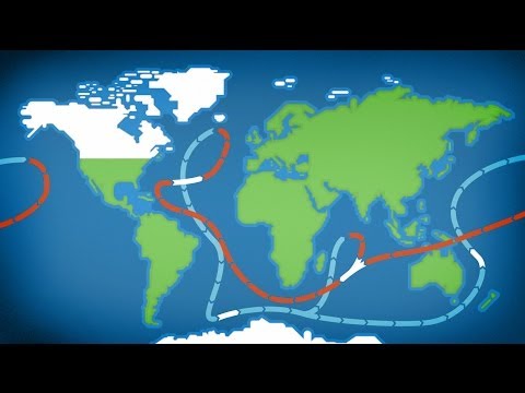 Photo: N43 and Hermes
A warm river inside the Atlantic Ocean that carries more water than every river on Earth combined — keeping Western Europe mild, fueling Atlantic hurricanes, and now showing signs of instability that could reshape coastlines on both sides of the ocean.
Source video: The Gulf Stream Explained · Kurzgesagt - In a Nutshell · approximately 6.3M views observed via yt-dlp on August 4, 2026. Independently researched by N43 and Hermes.
The Gulf Stream system: warm water (red) flows from the Gulf of Mexico up the US East Coast and across to Europe as the North Atlantic Drift. Cold water (blue) returns south via the Canary Current. The Labrador Current brings cold water south along the Canadian coast. Source: NOAA, Wikipedia.
01 A River in the Ocean
The Gulf Stream is a warm, swift Atlantic ocean current that originates in the Gulf of Mexico, flows through the Straits of Florida between Cuba and the Florida Keys, and then runs northward along the eastern coast of the United States. Near Cape Hatteras, North Carolina — around 36 degrees north latitude — it begins to veer eastward, eventually crossing the Atlantic toward Northwest Europe, where it is known as the North Atlantic Current or North Atlantic Drift. It is one of the strongest currents on Earth and the most studied ocean current in history.
The scale of the Gulf Stream is difficult to comprehend. At its narrowest point, the Straits of Florida, it is about 80 kilometres wide and 800 metres deep, and it transports approximately 30 million cubic metres of water per second. That is roughly 150 times the discharge of the Amazon River and more than the combined flow of every river on Earth. The water in the Gulf Stream moves at speeds of 1.5 to 2.5 metres per second at the surface, fast enough to be visible from space and to push ships off course in the age of sail. Its temperature can be 10 degrees Celsius warmer than the surrounding ocean, making it a vivid feature in infrared satellite imagery.
02 How It Forms
The Gulf Stream begins with the trade winds. These steady easterly winds, which blow from the northeast in the Northern Hemisphere, push warm surface water westward across the tropical Atlantic. This water piles up in the Caribbean Sea and the Gulf of Mexico, where it accumulates heat from the tropical sun. When this warm pool of water tries to escape, it is funneled through the narrow Straits of Florida and shoots northward along the continental shelf of the US East Coast. This is the Florida Current, the initial segment of what becomes the Gulf Stream.
As the current moves north, it is reinforced by the Antilles Current, which flows northward east of the Caribbean islands, and by the gyre of the Sargasso Sea — the slow, clockwise-circulating body of warm water at the centre of the North Atlantic subtropical gyre. By the time the combined flow reaches Cape Hatteras, it has become the full Gulf Stream, a powerful western boundary current. The process that makes it so strong on the western side of the Atlantic is called western intensification, a consequence of the Coriolis effect being stronger at higher latitudes. This asymmetry concentrates the gyre's flow on its western edge, producing a fast, narrow, intense current — the Gulf Stream — while the eastern side of the gyre has a much slower, broader return flow.
The Gulf Stream transports ~30 million cubic metres per second — roughly 25 times the combined flow of every river on Earth. Values: NOAA oceanographic data, Wikipedia river discharge estimates.
03 The Climate Engine
The Gulf Stream's most famous effect is making Western Europe warmer than its latitude would suggest. London, at 51 degrees north, has a January average temperature of about 5 degrees Celsius. Calgary, at 51 degrees north, averages minus 7 degrees in January. The difference — 12 degrees — is largely attributable to the heat the Gulf Stream and its extension, the North Atlantic Drift, deliver to the North Atlantic atmosphere. The mechanism is not direct heat blowing across the ocean; rather, the warm current heats the air above it, and prevailing westerly winds carry that warmth to the European coast.
The Gulf Stream also plays a critical role in the global climate system through its connection to the Atlantic Meridional Overturning Circulation, or AMOC. As the Gulf Stream carries warm water north, it cools and evaporates, becoming saltier and denser. In the Labrador Sea and the Nordic Seas, some of this water becomes cold and salty enough to sink — a process called deep-water formation. This sinking drives the thermohaline circulation: deep water flows south along the Atlantic floor, eventually reaching the Southern Ocean and the Pacific, while warm surface water flows north to replace it. The Gulf Stream is the surface arm of this loop, and the sinking in the North Atlantic is its engine. Without the Gulf Stream delivering warm water northward, the overturning circulation would weaken or cease.
04 Rings, Eddies, and Meanders
The Gulf Stream does not flow in a straight line. As it moves north along the US coast and then eastward into the Atlantic, it meanders — wavering north and south like a river in floodplain, but on a scale of hundreds of kilometres. These meanders occasionally pinch off, forming circular eddies called rings. When a northward meander breaks off on the north side of the stream, it traps warm Gulf Stream water in a clockwise-rotating ring called a warm-core ring. When a southward meander breaks off on the south side, it traps cold, nutrient-rich water in a counter-clockwise ring called a cold-core ring.
These rings can be 100 to 300 kilometres in diameter and persist for months to years, drifting slowly through the Atlantic. They are significant for marine life — cold-core rings bring nutrient-rich slope water into the warmer Sargasso Sea, creating hotspots of biological productivity. They are also significant for weather: warm-core rings can intensify storms and modify the thermal structure of the upper ocean in ways that affect hurricane formation. The Gulf Stream's meandering and ring-shedding behaviour is a natural consequence of hydrodynamic instability, and it makes the current's path highly variable on weekly to monthly timescales, even as its average position remains stable.
05 Hurricanes and the Gulf Stream
The Gulf Stream's warm waters are a critical factor in Atlantic hurricane formation and intensification. Hurricanes draw their energy from warm ocean water — specifically, they require sea surface temperatures above 26.5 degrees Celsius to a depth of at least 50 metres. The Gulf Stream, with its 25-to-28-degree waters, provides the fuel. When a hurricane crosses the Gulf Stream, it can intensify rapidly as it absorbs heat and moisture from the warm surface layer. The most devastating Atlantic hurricanes often follow tracks that take them over or near the Gulf Stream, including the Gulf of Mexico, where the current originates.
The relationship works in both directions. Hurricanes also affect the Gulf Stream. Powerful storms mix the upper ocean, bringing cold water from below to the surface in a process called upwelling. This cooling can leave a "cold wake" behind the storm that persists for days to weeks and can influence the intensity of subsequent storms that cross the same path. In 2005, Hurricane Katrina intensified rapidly as it crossed the warm Loop Current — a Gulf Stream tributary in the Gulf of Mexico — before making landfall in Louisiana. Understanding the interaction between the Gulf Stream and hurricanes is a priority for weather forecasting, since even small errors in predicting ocean temperature can mean the difference between a storm that fizzles and one that devastates a coast.
06 Is the Gulf Stream Weakening?
One of the most consequential questions in climate science is whether the Gulf Stream and the broader Atlantic overturning circulation are slowing down. The theory is straightforward: as Greenland's ice sheet melts, it dumps fresh water into the North Atlantic. Fresh water is less dense than salty water, and it dilutes the dense, cold, salty water that normally sinks to drive the overturning circulation. If the sinking weakens, the AMOC weakens, and the Gulf Stream could slow, reducing the heat delivered to Western Europe.
The evidence is mixed but increasingly concerning. A 2015 study published in Nature Climate Change suggested the AMOC had weakened by about 15 to 20 percent since the mid-twentieth century — though the observational record before 2004, when the RAPID array of monitoring buoys was deployed across the Atlantic at 26 degrees north, is sparse and relies partly on indirect proxies. Paleoclimate records show that the AMOC has collapsed in the past, particularly during the transition out of the last ice age, when massive pulses of meltwater from retreating ice sheets temporarily shut down deep-water formation and plunged the North Atlantic region into cold spells lasting centuries. The Intergovernmental Panel on Climate Change projects that the AMOC is very likely to weaken over the twenty-first century, though a complete collapse this century is considered unlikely but not impossible. If the Gulf Stream were to weaken significantly, the consequences would be profound: colder winters in Western Europe, faster sea-level rise along the US East Coast (since the current currently pulls water away from shore), disrupted rainfall patterns in Africa and Asia, and accelerated climate disruption on both sides of the Atlantic.
07 The Current That Connects
The Gulf Stream is more than an oceanographic feature — it is a climate connection between two continents. It links the Gulf of Mexico, where warm water accumulates under tropical sun, to the Norwegian Sea, where that same water, now cooled and sinking, begins a journey through the deep ocean that will eventually carry it around the globe. Along the way, it shapes the weather of the US East Coast, the climate of Western Europe, the formation of hurricanes, the productivity of fisheries, and the pace of climate change itself.
Benjamin Franklin mapped it to speed mail ships across the Atlantic. Today, satellites track it in real time, and instruments measure its flow from surface to seafloor. But the fundamental question — whether this planetary river will continue to flow at its current strength, or whether the warming climate is quietly undermining the engine that drives it — remains open. The Gulf Stream has been flowing since the current configuration of the Atlantic basin was established, roughly 3 million years ago. Whether it will flow at the same strength a century from now is one of the most important questions humanity has not yet answered.
References
- Wikipedia: Gulf Stream — comprehensive overview of formation, path, transport, and climate significance
- NOAA, Gulf Stream facts — National Ocean Service educational resource on the current's properties and effects
- NOAA, Atlantic Oceanographic and Meteorological Laboratory — Gulf Stream research — monitoring programs including the RAPID array
- IPCC AR6, Working Group 1 Report, Chapter 9: Ocean, Cryosphere and Sea Level Change — AMOC projections and uncertainty analysis
- Source video: The Gulf Stream Explained (Kurzgesagt - In a Nutshell, ~6.3M views, observed August 4, 2026)
By N43 and Hermes for Sailor Bob News.


