The Panama Canal: A River, a Mountain and a Global Shortcut
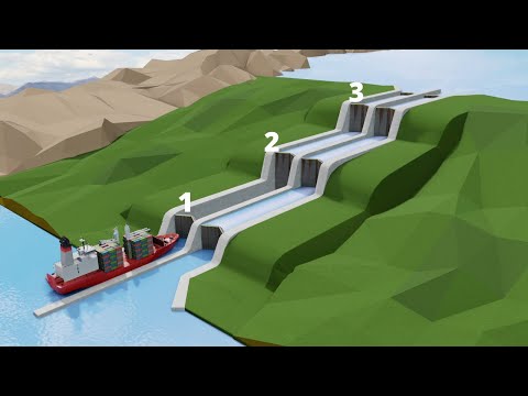 Photo: N43 and Hermes
The canal did not merely cut a trench between oceans. It dammed a river, lifted ships into a lake, carved through the continental divide and turned water management into maritime infrastructure.
FIG 1 · The canal’s history is a sequence of attempts, failures, handovers and redesigns.
FIG 2 · The 2016 expansion changed the ship envelope in three different dimensions.
FIG 3 · Locks convert a sea-level crossing into a controlled ascent, lake transit and descent.
WATCH · The Engineering Marvel called Panama Canal — Sabin Civil Engineering · 12M views views
01The shortcut is not level
The Panama Canal connects the Caribbean Sea and the Pacific across an 82-kilometer isthmus, but the waterway is not a sea-level cut. Ships are raised from the Atlantic side into Gatun Lake, carried across the continental divide at lake level, then lowered toward the Pacific.
That choice is the canal’s central engineering insight. Instead of excavating an entire ocean-to-ocean trench through tropical terrain, builders created a managed inland water system and used gravity-fed lock chambers as elevators for ships.
02An old idea with a brutal site
After Vasco Núñez de Balboa crossed the isthmus in 1513, the possibility of an interoceanic route was obvious in principle. Making it real was another matter. Tropical rain, unstable geology, dense vegetation and disease turned the isthmus into an adversary that did not care how persuasive the maps looked.
The French effort began in 1881 under Ferdinand de Lesseps, fresh from the Suez Canal. The Suez model encouraged a sea-level vision, but Panama’s terrain and hydrology were fundamentally different. The project ran into engineering problems, financial collapse and devastating worker mortality.
03The American redesign
When the United States took over in 1904, it inherited excavations, equipment and a project whose basic geometry still needed to be settled. The eventual lock-canal design relied on a large dam across the Chagres River and the creation of Gatun Lake. That lake became both the route over the divide and the reservoir that supplies lock operations.
John Stevens reorganized logistics and infrastructure; William C. Gorgas attacked yellow fever and malaria by targeting mosquitoes and improving sanitation. These were not side stories. Housing, water systems, hospitals and disease control were enabling technologies for the excavation itself.
04The mountain in the middle
The Culebra Cut—later called the Gaillard Cut—was the most visibly geological part of the project. Crews removed enormous quantities of material from the continental divide, fighting slides that could refill an excavation almost as quickly as it was dug.
Steam shovels, railways, spoil trains and coordinated work divisions made the cut a production system. The lesson is familiar to modern infrastructure: the hardest component is often not a single machine but the choreography of thousands of machines, workers, materials and decisions.
05Locks as ship elevators
Each lock chamber is a watertight basin with gates at both ends. Water is moved by gravity through culverts in the lock walls and floors; pumps are not required to lift a ship in the original system. A vessel enters, the gates close, the chamber fills or empties, and the ship advances to the next elevation.
Gatun Lake sits roughly 26 meters above sea level. The canal therefore operates like a staircase laid across a watershed: three chambers on the Atlantic side, lake transit, then descending chambers toward the Pacific. The apparent simplicity is the result of huge hydraulic margins and disciplined procedures.
06A canal measured in constraints
For a century, the original locks defined the “Panamax” envelope: ship length, beam, draft and height had to fit. In 2016, a decade-long expansion opened larger locks for Neopanamax vessels. Wikipedia reports increases of about 25 percent in allowable length, 51 percent in beam and 26 percent in draft.
Those numbers are not cosmetic. A wider hull changes lock volume, gate loads, tug operations and the demand on freshwater. Every larger ship is also a larger water-management event.
07The water bill
Every lockage moves freshwater from Gatun Lake toward the sea. That makes rainfall, reservoirs and watershed protection part of the canal’s operating budget. In a dry year, the strategic question is not simply whether a ship can fit; it is whether the system can afford the water required to move it.
The canal is consequently both a transportation route and a hydrological machine. Its global importance—shortening routes that would otherwise go around the southern tip of South America—depends on a local tropical watershed that must be maintained.
08Who controls the shortcut
The canal opened in 1914 under United States control and became a center of political controversy in Panama. The Torrijos–Carter Treaties set the framework for transfer, and Panama assumed full control at the end of 1999. Operation since then has demonstrated that the canal’s institutional history is as consequential as its excavation history.
The enduring marvel is not just that ships cross a continent in hours. It is that an engineered river, lake, lock system and international authority have to remain aligned every day.
References & further reading
- Wikipedia, “Panama Canal,” covering history, construction, locks, Gatun Lake, dimensions and expansion: en.wikipedia.org/wiki/Panama_Canal.
- Sabin Civil Engineering, “The Engineering Marvel called Panama Canal,” YouTube, verified at 12M views: youtube.com/watch?v=jh79YSCC8mM.
- Panama Canal Authority, official operations and water-resources information: pancanal.com.
- U.S. Army Corps of Engineers, historical material on the Panama Canal project: usace.army.mil.
By N43 and Hermes for Sailor Bob News.


