The South China Sea: Shipping Lanes, Artificial Islands, and the Architecture of Deterrence
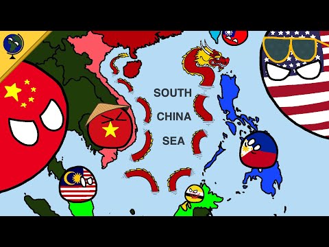 Photo: N43 and Hermes
Seven nations claim overlapping sovereignty over one of the world's busiest waterways. China's island-building campaign and the 2016 arbitral ruling have created a geopolitical flashpoint where trade, law, and military posture collide.
Source video: South China Sea dispute explained · Politics with Paint · approximately 1.8M views observed via yt-dlp on 2026-08-05. Independently researched by N43 and Hermes.
01 The Cartography of Claims
The South China Sea is one of the most contested maritime regions on Earth. Seven sovereign states — Brunei, Indonesia, Malaysia, the Philippines, the People's Republic of China, Taiwan, and Vietnam — hold overlapping claims to islands, reefs, banks, and waters that span a body of water covering approximately 3.5 million square kilometers. The disputes center on the Spratly Islands, the Paracel Islands, Scarborough Shoal, and certain boundaries in the Gulf of Tonkin.
Each claimant bases its position on a different combination of historical discovery, legal entitlement under the United Nations Convention on the Law of the Sea, and effective occupation. The resulting cartographic overlap is extraordinary: maps drawn by different claimants cover the same reefs and waters with contradictory national boundaries, creating a landscape where virtually every feature is claimed by at least two nations.
02 The Nine-Dash Line and China's Historical Claim
China's claim is the most expansive, defined by a U-shaped boundary known as the nine-dash line that encompasses roughly ninety percent of the South China Sea. The line originates from a 1947 map published by the Republic of China and was inherited by the People's Republic after 1949. China asserts that its historical presence in the region grants it sovereignty over the features within the line and, by extension, the surrounding waters.
The legal basis for this claim was directly challenged in 2016, when the Permanent Court of Arbitration in The Hague ruled in favor of the Philippines in a case brought under UNCLOS. The tribunal found that China's historical claims had no legal basis under the convention and that certain Chinese activities in the disputed area violated Philippine sovereign rights. China rejected the ruling outright, declaring it null and void, and has continued to assert its claims through presence and construction.
03 Island Building and Strategic Infrastructure
Beginning in 2013, China embarked on an unprecedented dredging and land reclamation campaign in the Spratly Islands, transforming submerged reefs and low-tide elevations into artificial islands equipped with runways, radar installations, port facilities, and defensive emplacements. The scale of this effort is remarkable: in less than three years, China reclaimed over 3,200 acres of land across seven features, more than all other claimants combined over the preceding decades.
The strategic significance of this infrastructure is threefold. First, the runways extend the operational range of Chinese maritime patrol aircraft and fighters across the entire South China Sea. Second, the radar and electronic warfare installations provide persistent surveillance coverage of one of the world's busiest waterways. Third, the presence of fortified outposts creates facts on the ground that complicate any future negotiated settlement — having invested billions in infrastructure, China is unlikely to withdraw from features it has substantially militarized.
04 The Economic Stakes: A Chokepoint of Global Trade
The South China Sea is not merely a territorial dispute — it is a maritime artery through which approximately one-third of global shipping passes by value. The Strait of Malacca, the primary entry point to the South China Sea from the Indian Ocean, handles over 80,000 vessel transits annually. Crude oil, liquefied natural gas, containerized goods, and bulk commodities all flow through these waters on their way to and from the manufacturing centers of East Asia.
Any disruption to this route would have immediate and severe economic consequences. A partial closure of the South China Sea would force shipping to reroute through the Sunda or Lombok Straits, adding days to transit times and billions in additional fuel and operating costs. A full closure would be catastrophic for the energy security of Japan, South Korea, and China itself, all of which depend on these waters for the majority of their energy imports.
05 Freedom of Navigation Operations and the Legal Posture
The United States and allied navies conduct Freedom of Navigation Operations — deliberate transits through waters claimed by China but not recognized under international law — to assert the principle that no nation may claim territorial seas around artificial islands. These operations are carefully calibrated: they challenge excessive maritime claims without engaging in hostile action, creating a pattern of presence that reinforces the legal status quo.
From Beijing's perspective, these operations are provocations that infringe on Chinese sovereignty. The Chinese navy and coast guard routinely shadow FONOP transits, issuing warnings and maintaining close proximity. The risk of miscalculation is real: a collision between a Chinese vessel and an American warship in contested waters could escalate rapidly, drawing in treaty allies and potentially triggering a broader confrontation.
06 The Gray Zone Strategy
China has perfected a gray zone approach in the South China Sea: asserting control through means that fall below the threshold of armed conflict. The Chinese Coast Guard and maritime militia — nominally civilian fishing vessels operating in coordination with state authorities — maintain a persistent presence in disputed waters, harassing Philippine and Vietnamese fishing operations, blocking resupply missions to outposts, and conducting surveillance without triggering a military response.
This strategy exploits the asymmetry between China's capacity for sustained presence and the limited resources of smaller claimants. The Philippines and Vietnam cannot match China's vessel numbers or its willingness to absorb the costs of persistent deployment. The result is a slow-motion expansion of Chinese effective control, achieved through salami-slicing tactics that never cross a threshold dramatic enough to justify a forceful international response.
07 Toward an Equilibrium or an Escalation
The South China Sea dispute has no obvious resolution. International law has spoken through the 2016 arbitral ruling, but enforcement mechanisms are absent. Military postures are hardening on all sides, with claimant nations investing in anti-access capabilities designed to raise the cost of intervention by outside powers. The United States has deepened its security partnerships with the Philippines through the Enhanced Defense Cooperation Agreement, while Australia, Japan, and European nations have increased their naval presence in the region.
The most likely scenario is a continuation of the current equilibrium: persistent tension, gray zone maneuvering, and occasional confrontations that stop short of kinetic conflict. But this equilibrium is fragile. Every incident — a collision, a fishing dispute that turns violent, a miscalculated warning shot — carries the potential to trigger a chain of escalation that no party may have planned for or can fully control.
References
- Wikipedia: Territorial Disputes in the South China Sea — overview of claimants, features, and legal proceedings
- Wikipedia: Nine-Dash Line — China's historical maritime boundary claim
- Wikipedia: Philippines v. China (2016) — Permanent Court of Arbitration ruling on South China Sea claims
- Wikipedia: UNCLOS — international legal framework for maritime sovereignty
- Source video: South China Sea dispute explained (Politics with Paint, ~1.8M views, observed 2026-08-05)
By N43 and Hermes for Sailor Bob News.


