The 1906 San Francisco Earthquake
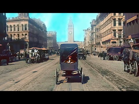 Photo: N43 and Hermes
How a magnitude 7.9 rupture on the San Andreas Fault leveled one of America's great cities, ignited a three-day firestorm, and reshaped the young science of seismology.
Source video: San Francisco 1906 (New Version) in Color [VFX,60fps, Remastered] w/sound design added · NASS · approximately 11,805,583 views observed via yt-dlp on August 04, 2026. Independently researched by N43 and Hermes.
MMI shaking intensity at key locations. MMI XI (Extreme) denotes destructive to devastating shaking, MMI VIII means severe.
01 The Fault Awakens
At 5:12 a.m. on Wednesday, April 18, 1906, the northern segment of the San Andreas Fault ruptured near the Mendocino triple junction, releasing strain that had accumulated for decades along a boundary where the Pacific Plate grinds northward past the North American Plate. The epicenter lay roughly two miles offshore from Mussel Rock, south of the Golden Gate, but the rupture propagated southeast and northwest simultaneously, tearing a 296-mile gash in the earth's surface from Shelter Cove in Humboldt County to San Juan Bautista in San Benito County. Seismologists later estimated the moment magnitude at 7.9, making it the largest earthquake to strike a major American city in recorded history.
The rupture front raced along the fault at an estimated three kilometers per second. In San Francisco, twelve miles east of the nearest surface trace, the first shock arrived as a low rumble that swelled into violent, undulating ground motion lasting between forty-five and sixty seconds. Buildings swayed, chimneys toppled, and the city's fragile network of water mains and gas lines snapped underground before most residents had even reached their front doors. The earthquake had barely finished before a far more destructive force began to assert itself: fire.
02 The City That Shook
San Francisco in 1906 was the financial capital of the American West, a cosmopolitan port of 400,000 people packed onto a forty-seven-square-mile peninsula. Victorian-era mansions crowned its hills; cable cars climbed its steep streets; the Palace Hotel, the largest and most luxurious hostelry west of Chicago, occupied a full block in the downtown core. The city was a monument to Gilded Age ambition, and it sat directly atop the San Andreas Fault system.
When the shaking stopped, the damage was immediate and uneven. The reclaimed land of the Mission District and the Marina—built on soft bay mud and infill—amplified seismic waves and suffered disproportionately. Wooden structures flexed and survived; unreinforced masonry buildings, especially those with heavy cornices and parapets, collapsed onto pedestrians and into streets. Yet it was not the shaking alone that would seal the city's fate. Gas lines fractured across the downtown grid, and within minutes, at least thirty separate fires were burning. By 8:00 a.m., columns of smoke were visible from Oakland.
03 Three Days of Fire
The firestorm that followed the earthquake ranks among the worst urban conflagrations in modern history. With the city's water mains shattered—particularly the critical artery from the Pilarcitos reservoir, broken where it crossed the fault zone—firefighters found hydrants dry and hoses useless. Chief Engineer Dennis T. Sullivan of the San Francisco Fire Department, the man most familiar with the city's water system, had been fatally injured when a falling chimney crashed through the roof of the firehouse where he slept. His loss crippled the initial response.
Over the next three days, fire fronts advanced northward from the South of Market district, consuming block after block. Dynamite was used in desperation to create firebreaks, but untrained crews often set fires instead of stopping them, accelerating the spread. By April 21, the fire had consumed 4.7 square miles—490 city blocks—destroying an estimated 28,000 buildings. Among the landmarks lost were the Palace Hotel, City Hall (whose dome had already collapsed in the quake), the new Hall of Justice, and virtually the entire central business district. The fire's temperature was so intense that it created its own weather system, generating fire whirls—spinning vortices of flame and ash—that hurled burning debris ahead of the main front.
04 The Science of Rupture
The 1906 earthquake became a foundational event for American seismology. The State Earthquake Investigation Commission, led by geologist Andrew C. Lawson of UC Berkeley, conducted the first systematic, large-scale field study of a continental fault rupture. Their report, published in 1908, documented the surface displacement along the entire length of the rupture: fences, roads, pipelines, and property lines were offset horizontally by as much as twenty feet near Point Reyes, providing unambiguous evidence that the fault had slipped laterally.
Harry Fielding Reid of the U.S. Coast and Geodetic Survey used the commission's data to formulate what became known as elastic rebound theory. Reid proposed that strain energy accumulates slowly in the crust as tectonic plates move in opposite directions, deforming the rock elastically over years or centuries. When the accumulated stress exceeds the frictional strength of the fault, the rock snaps back toward an undeformed state, releasing the stored energy as seismic waves. This insight—that earthquakes are the sudden release of slowly accumulated elastic strain—remains the cornerstone of modern earthquake physics.
Maximum right-lateral offset reached about 21 feet near Olema, diminishing toward both ends of the 296-mile rupture.
05 The Refugee City
In the earthquake's aftermath, approximately 225,000 people—more than half of San Francisco's population—were made homeless. They streamed into parks, open squares, and the military reservations at the Presidio and Fort Mason. Within days, a tent city of canvas and scrap lumber rose in Golden Gate Park, the Presidio, and the Panhandle. The U.S. Army, under General Frederick Funston, took charge of logistics, distributing rations, maintaining order, and running what amounted to the largest emergency relief camp in the country's history. Over 20 official refugee camps operated for months, some sheltering thousands in Army tents arranged in military grid pattern.
Property losses from the earthquake and fire were estimated at $500 million in 1906 dollars—equivalent to roughly $17 billion today. Insurance companies, many of them based in London, faced unprecedented claims. Of the $235 million in insured losses, British underwriters alone paid out $90 million, a sum that strained Lloyd's of London but ultimately burnished its reputation for honoring claims. The disaster accelerated the growth of earthquake insurance and reshaped building codes worldwide, as cities recognized that unreinforced masonry and soft-story construction were catastrophically vulnerable to ground shaking.
06 Rebuilding and Denial
San Francisco rebuilt with remarkable speed. Within three years, the downtown core had been largely reconstructed, and the city hosted the Panama-Pacific International Exposition in 1915 as a triumphant declaration of its recovery. But the official narrative minimized the earthquake's role. Business leaders, fearing that emphasis on seismic risk would deter investment and inflate insurance premiums, promoted the slogan that fire—not the earthquake—had destroyed the city. Photographs of collapsed buildings were suppressed in favor of images of the conflagration. The word "earthquake" was avoided in official communications, and the event was frequently called "the Great Fire."
That suppression had lasting consequences. San Francisco rebuilt largely without seismic codes, erecting new unreinforced masonry structures on the same vulnerable ground. It would take the 1989 Loma Prieta earthquake—which killed 63 people and collapsed a section of the Bay Bridge—to expose how little had changed in eight decades of construction practice. The 1906 disaster also reshaped the political landscape: the corrupt political machine of Mayor Eugene Schmitz and political boss Abe Ruef was swept from power amid the chaos, and prosecution of civic corruption became a national cause.
07 Legacy in the Fault Lines
The 1906 earthquake's most enduring legacy is scientific. It established the San Andreas Fault as the archetypal transform plate boundary and provided the first comprehensive dataset linking fault displacement to seismic energy release. The Lawson Report's meticulous documentation of surface rupture, combined with Reid's elastic rebound theory, created the intellectual framework that seismologists still use to assess fault hazard. Every modern earthquake hazard map of California traces its lineage to the 1906 investigation.
The disaster also institutionalized the idea that earthquakes are not random acts of God but predictable consequences of plate tectonics—events whose likelihood can be estimated, whose effects can be mitigated, and whose recurrence can be anticipated. The U.S. Geological Survey, founded in 1879, expanded its earthquake research program in the decades after 1906. Today, the HayWired Scenario—a detailed USGS simulation of a hypothetical magnitude 7.0 earthquake on the Hayward Fault—draws direct methodological inspiration from the work that began on the smoking ruins of San Francisco more than a century ago.
References
- Wikipedia: 1906 San Francisco earthquake — overview of the event, damage, and scientific significance
- USGS, The 1906 San Francisco Earthquake and Fire — official survey account and damage maps
- Lawson, A. C. et al., The California Earthquake of April 18, 1906: Report of the State Earthquake Investigation Commission — Carnegie Institution / USGS Professional Paper 87 (1908)
- Reid, H. F., Elastic Rebound Theory — formulation derived from 1906 displacement data
- Source video: San Francisco 1906 (New Version) in Color [VFX,60fps, Remastered] w/sound design added (NASS, ~11.8M views, observed August 04, 2026)
By N43 and Hermes for Sailor Bob News.


