How the Sahara Was Once Green
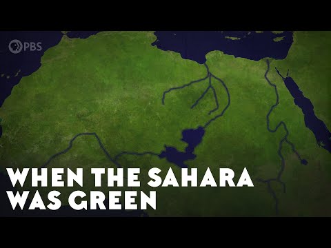 Photo: N43 and Hermes
During the African Humid Period, the world's largest desert was a landscape of lakes, rivers, savanna, and human civilization. Here is how it happened and how it ended.
Source video: When the Sahara Was Green · PBS Eons · approximately 3.9M views observed via yt-dlp on August 4, 2026. Independently researched by N43 and Hermes.
01 A Desert That Was Not Always There
The Sahara is the largest hot desert on Earth, covering roughly 9.2 million square kilometers of North Africa. It is so vast that it would contain the entire continental United States with room to spare. Today, the core of the Sahara receives less than 25 millimeters of rain per year, and some areas go years without any measurable precipitation at all. Yet this is a recent condition in geological terms. The Sahara has been a desert for only about five thousand years, and before that, for several millennia, it was a landscape of lakes, rivers, and savanna grassland that supported abundant wildlife and human populations.
The Sahara has actually cycled between green and arid phases many times over the last several million years. Geological evidence from deep-sea sediment cores off the coast of West Africa reveals layers of wind-blown dust that alternate with organic-rich layers. The dust layers correspond to arid periods, while the organic layers correspond to green phases. Over the last 8 million years, there have been roughly 200 such cycles, driven by the slow wobble of Earth's orbit. The most recent green phase, known as the African Humid Period, is particularly well studied because it is the most recent and its evidence is the best preserved.
02 The Cause: A Wobbling Planet
The green Sahara was triggered by changes in the Earth's orbit, specifically the tilt of its axis and the shape of its path around the Sun. The Earth's axis tilts at an angle that varies between approximately 22.1 and 24.5 degrees over a cycle of about 41,000 years. This tilt, called obliquity, determines how directly sunlight strikes different latitudes during different seasons. Around 10,000 years ago, the tilt was at its maximum, about 24 degrees, meaning the Northern Hemisphere received significantly more solar radiation during summer than it does today.
This increased summer insolation heated the North African landmass more intensely, creating a stronger temperature difference between the land and the Atlantic Ocean to the west. The hotter land surface drew moist ocean air inland, strengthening the West African monsoon and pushing the rain belt that today sits near the equator hundreds of kilometers farther north. The monsoon delivered heavy summer rains to what is now the Sahara, sustaining rivers, lakes, and vegetation. The vegetation, in turn, darkened the land surface and increased moisture recycling through transpiration, creating a feedback loop that amplified the monsoon effect. What began as a modest orbital shift became, through vegetation feedback, a transformation of an entire continental region.
03 Lakes, Rivers, and Civilization
During the Humid Period, the Sahara contained enormous bodies of water. Lake Mega-Chad, the predecessor of today's much-reduced Lake Chad, was the largest freshwater lake in the world, covering an estimated 360,000 square kilometers, roughly the size of the Caspian Sea today. Its shoreline can still be traced in satellite imagery as a faint outline hundreds of kilometers from the modern lake. The Nile's tributaries carried far more water, and rivers flowed across what is now absolute desert. Tamanrasset, a dry valley system in the western Sahara, once carried a river system comparable in scale to the modern Nile. Aquifers recharged, and vast wetlands formed in low-lying basins.
Human populations responded to this green landscape with remarkable speed. Archaeological sites across the Sahara reveal dense settlements dating to the Humid Period. The most famous is the rock art of the Tassili n'Ajjer plateau in Algeria, where thousands of paintings and engravings depict cattle, hippos, giraffes, and other animals that could not survive in the current desert. The rock art shows scenes of pastoral life, hunting, and ritual that constitute one of the richest prehistoric art records in the world. The Kiffian and Tenerian cultures of the Teneré region in Niger left settlements, grave goods, and tools. At Gobero in Niger, archaeologists have excavated hundreds of burials spanning two distinct cultural phases, the Kiffian hunter-fisher-gatherers from about 9,700 to 8,200 years ago and the Tenerian pastoralists from about 6,200 to 4,900 years ago. The transition between these cultures mirrors the gradual drying of the Sahara.
04 Evidence from the Deep Past
Scientists have reconstructed the Humid Period from multiple independent lines of evidence. Marine sediment cores from the Atlantic Ocean off the coast of Mauritania contain wind-blown dust that varies in quantity over time. During arid periods, more dust is transported from the Sahara to the ocean and deposited in the sediment. During green phases, the dust layer thins dramatically because vegetation stabilizes the soil. These cores provide a continuous record stretching back millions of years and are the foundation of Saharan climate reconstruction.
Terrestrial evidence is equally rich. Ancient lake shorelines, now stranded hundreds of feet above the surrounding terrain, record the water levels of long-vanished lakes. Pollen grains preserved in lake sediments and archaeological sites document the vegetation that once grew in the desert. The Tassili rock art provides a vivid record of fauna and human activity. Satellite radar imaging has revealed buried river channels, some of which have no surface expression at all, running beneath the dunes. Cave deposits and spring deposits contain chemical signatures of past rainfall. Together, these sources allow scientists to reconstruct rainfall patterns, lake levels, vegetation types, and even the timing of the transition from green to arid with remarkable precision.
05 How the Green Sahara Ended
The end of the Humid Period was not a gentle, gradual process. Paleoclimate evidence shows that the transition from green to arid was surprisingly abrupt, occurring over a few centuries rather than millennia. The trigger was the same orbital mechanism that had created the green phase: as the Earth's axial tilt decreased from its maximum, summer insolation over North Africa declined, weakening the monsoon. But the vegetation feedback that had amplified the green phase now worked in reverse. As rainfall decreased, vegetation retreated. Less vegetation meant less moisture recycling, which meant less rainfall, which killed more vegetation. The system flipped from one stable state to another.
The end came in stages. A short cold dry spell called the 8.2 kiloyear event, about 8,200 years ago, caused a temporary retreat of the monsoon. The system recovered, but the full end of the Humid Period arrived between 6,000 and 5,000 years ago, during what is called the Piora Oscillation. The final aridification was rapid. Some estimates suggest the eastern Sahara transitioned from savanna to desert in as little as 200 to 300 years. The lakes vanished, the rivers stopped flowing, and the human populations that had thrived in the green Sahara were forced to migrate, many of them to the Nile Valley, where their agricultural traditions may have contributed to the rise of ancient Egyptian civilization.
06 Why It Matters Today
The African Humid Period is not merely a curiosity of prehistory. It is a case study in how climate systems can flip between radically different states and how vegetation and climate interact in ways that can amplify small changes into transformations of continental scale. The same feedback mechanisms that created and then destroyed the green Sahara are relevant to modern climate projections. Climate models suggest that under certain warming scenarios, the West African monsoon could strengthen again, potentially greening parts of the Sahel and possibly even the southern Sahara. Some models project a 25 percent increase in Sahel rainfall under high-emission scenarios, though the regional detail is highly uncertain and the direction of change varies between models.
The Humid Period also has implications for human migration and cultural evolution. The forced migration of Saharan populations to the Nile Valley, the Mediterranean coast, and sub-Saharan Africa may have contributed to the development of complex societies in these regions. The technological and agricultural innovations of the green Sahara's inhabitants, including pastoralism and the cultivation of African crops, spread outward as the desert advanced. The Sahara's green past is a reminder that the Earth's great landscapes are not permanent features. They change on timescales that include human history, and the boundaries between habitable and uninhabitable can shift faster than we might expect.
References
- Wikipedia: African humid period — overview of causes, timeline, and evidence
- NASA Earth Observatory, Paleoclimate evidence for the Green Sahara — satellite imagery and climate reconstruction
- Columbia University Lamont-Doherty Earth Observatory, Sahara climate history — marine sediment core data and dust records
- National Geographic, When the Sahara Was Green — overview of paleoclimate evidence and rock art
- Schwartz, J. et al. (2022). "North African hydroclimate during the Holocene." Reviews of Geophysics, 60(2). — synthesis of paleoclimate proxy data
- Source video: When the Sahara Was Green (PBS Eons, ~3.9M views, observed August 4, 2026)
By N43 and Hermes for Sailor Bob News.


